Nederlands English

2019-05-10: You may want to look at our new (beta) interface here. Refresh Ctrl-F5 often!
2019-09-12: Somehow the 3 days in advance (Sunday) had images of 2 days in advance (Saturday). Under investigation.

Please feel free to support me in the costs of hosting:

Regional   Atmospheric   Soaring   Prediction
Boundary Layer Information Prediction MAP
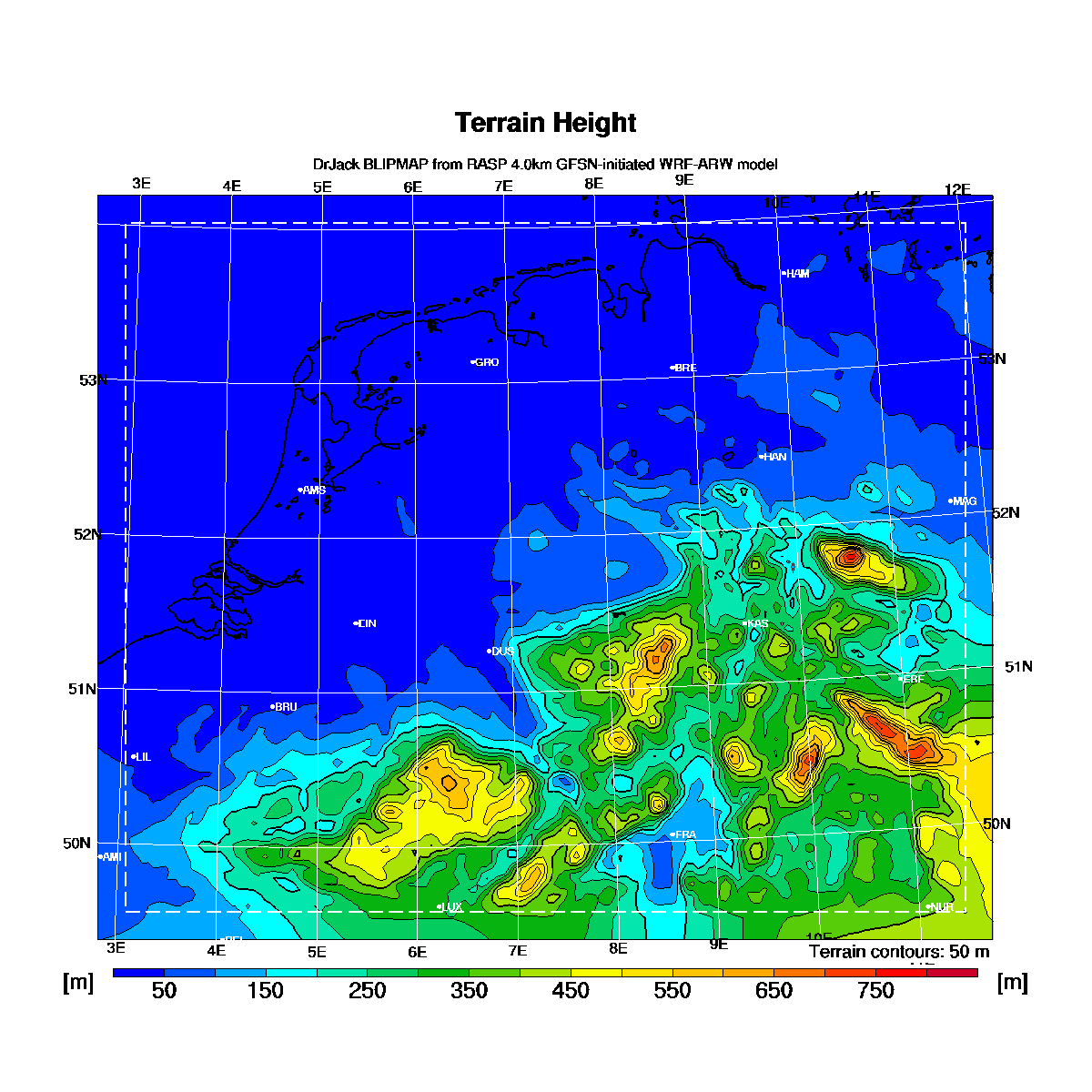
The Netherlands, North Belgium and Northwest Germany

The atmospheric Boundary Layer (BL) is the vertical region above the surface within which air has been mixed by thermal or windshear eddies, i.e. the region where gliders, hanggliders and paragliders normally fly. The RASP BLIPMAP model is developed by Dr. John W. (Jack) Glendening and is a WRF model specifically adapted for these gliders. The basic parameters are described here and all parameters here. A description of all parameters in German can be found here. If you have any remarks or questions, please email rasp@blipmaps.nl.
The results are available for today at 08:30 local time, for tomorrow at 09:30 and for the day after tomorrow at 10:30 at the latest and depending on the weather sometimes up till 30 minutes earlier. Animations have only been made for those parameters of which the legenda doesn't change througout the day. After midnight all results are copied to one day earlier. Due to this until 10:30 no results are available for the day after tomorrow. How actual the forecast is can be derived from the number of hours that is noted in each picture before the text "hrFcst@". This is the difference between the model starttime and the time at which the forecast is valid. If you have difficulties distinguishing colors then thishelps.

Other areas for which RASP BLIPMAP predictions are available on this server: North- and Central France
Overview of areas for which RASP BLIPMAP predictions are available world-wide

PARAMETERS [Description] Yesterday TODAY (local time) Tomorrow The day after tomorrow 3 days 4 days
Thermal:
Surface Temperature    


Normalized Surface Sun    


Height of Boundary Layer Top    


Height of Critical Updraft Strength (<0,9 m/s)    


Maximum Thermalling Height including cloudbase limitations    


Thermal Height Uncertainty    


Thermal Updradft Velocity for 0,9 m/s sinkrate    


Buoyancy/Shear Ratio    


Thermal Updraft Velocity and B/S ratio    


Wind:
Surface wind    


Boundary Layer Average Wind    


Wind at the Boundary Layer Top    


Boundary Layer Wind Shear    


BL Convergence    


Height at which BL Max. Up/Down Motion occurs    


Clouds:
Cumulus Cloudbase where CuPotential>0    


OvercastDevelopment Cloudbase where ODpotential>0    


BL Cloud Cover    


Surface Dew Point Temperature    


CAPE    


1 hr Accumulated Rain    


Wave/Upper-level:
Vertical velocity at 955mb (m)    


Vertical velocity at 899mb (m)    


Vertical velocity at 846mb (m)    


Vertical velocity at 795mb (m)    


Vertical velocity at 701mb (m)    


Vertical velocity at 616mb (m)    


Vertical velocity at 540mb (m)    


Vertical Velocity Slice through location of Max. Vertical Velocity at wind-parallel angle    


Soundings and locations:
AMS (Amsterdam)   0830
0900
0930
1000
1030
1100
1130
1200
1230
1300
1330
1400
1430
1500
1530
1600
1630
1700
1730
1800
1830
1900
EIN (Eindhoven)   0830
0900
0930
1000
1030
1100
1130
1200
1230
1300
1330
1400
1430
1500
1530
1600
1630
1700
1730
1800
1830
1900
GRO (Groningen)   0830
0900
0930
1000
1030
1100
1130
1200
1230
1300
1330
1400
1430
1500
1530
1600
1630
1700
1730
1800
1830
1900
DUS (Dusseldorf)   0830
0900
0930
1000
1030
1100
1130
1200
1230
1300
1330
1400
1430
1500
1530
1600
1630
1700
1730
1800
1830
1900
BRE (Bremen)   0830
0900
0930
1000
1030
1100
1130
1200
1230
1300
1330
1400
1430
1500
1530
1600
1630
1700
1730
1800
1830
1900
KAS (Kassel)   0830
0900
0930
1000
1030
1100
1130
1200
1230
1300
1330
1400
1430
1500
1530
1600
1630
1700
1730
1800
1830
1900
HAN (Hannover)   0830
0900
0930
1000
1030
1100
1130
1200
1230
1300
1330
1400
1430
1500
1530
1600
1630
1700
1730
1800
1830
1900
HAM (Hamburg)   0830
0900
0930
1000
1030
1100
1130
1200
1230
1300
1330
1400
1430
1500
1530
1600
1630
1700
1730
1800
1830
1900
ERF (Erfurt)   0830
0900
0930
1000
1030
1100
1130
1200
1230
1300
1330
1400
1430
1500
1530
1600
1630
1700
1730
1800
1830
1900
MAG (Magneburg)   0830
0900
0930
1000
1030
1100
1130
1200
1230
1300
1330
1400
1430
1500
1530
1600
1630
1700
1730
1800
1830
1900
BRU (Brussel)   0830
0900
0930
1000
1030
1100
1130
1200
1230
1300
1330
1400
1430
1500
1530
1600
1630
1700
1730
1800
1830
1900
LUX (Luxemburg)   0830
0900
0930
1000
1030
1100
1130
1200
1230
1300
1330
1400
1430
1500
1530
1600
1630
1700
1730
1800
1830
1900
FRA (Frankfurt)   0830
0900
0930
1000
1030
1100
1130
1200
1230
1300
1330
1400
1430
1500
1530
1600
1630
1700
1730
1800
1830
1900
NUR (Nurnberg)   0830
0900
0930
1000
1030
1100
1130
1200
1230
1300
1330
1400
1430
1500
1530
1600
1630
1700
1730
1800
1830
1900
LIL (Lille)   0830
0900
0930
1000
1030
1100
1130
1200
1230
1300
1330
1400
1430
1500
1530
1600
1630
1700
1730
1800
1830
1900
LML (Lemelerveld)   0830
0900
0930
1000
1030
1100
1130
1200
1230
1300
1330
1400
1430
1500
1530
1600
1630
1700
1730
1800
1830
1900
Other:
Ground level  

50m

10m
Experimental:
Potential flight distance   Total